History of our area
The Worimi are the traditional owners of the Port Stephens area.
The area remains important for the Worimi people and traditional sites provide important information about their relationship and special connection with the lands. The Worimi nation, which envelops the Port Stephens local government area, extends from the Hunter River in the south to Forster in the north and as far west as the Barrington Tops and Maitland. The Worimi people spoke the Gathang language.
Read more below.
The landscape includes an extraordinary number of Aboriginal cultural sites that pre-date the arrival of non-Aboriginal people to the area. Port Stephens and the wider region is home to numerous sites of deep cultural significance, from the area now known as the Worimi Conservation Lands of the Stockton Bight to significant relic sites, including canoe trees at Little Beach. In the area stretching from Wallis Lake to Newcastle there are 37 recorded Ceremonial Sites (stone arrangements, bora grounds, carved trees and burial sites), 115 recorded campsites (mia mia, scarred tree, open campsite, shelter with deposit, well, fish trap, abraded grooves and quarries) and 97 middens. Four middens and a burial site are located at the base of Yacaaba Head. Middens are located at Fingal Spit, Anna Bay, Schnapper Point, Boat Harbour, Skate Bay and Fishermans Bay. There is a burial site at Skate Bay and grinding grooves at Morna Point.
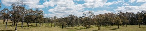
The local environment was favourable for hunter-gatherer living. The Worimi's non-destructive lifestyle was in such sympathy with the environment that it had already lasted tens of thousands of years and would have continued long into the future if the white invasion had not taken place.
Their knowledge of plants and animals has not been surpassed. Canoes were made from the bark of the Stringybark tree (Punnah) E. obliqua or She Oak. The ends were plugged with clay and when in use a fire always burned on a bed of clay at the back. Paddles made of seasoned hardwood were shaped like a large spoon and these paddles were used in a kneeling position from the middle of the 4.5m canoe. Fishing lines were made from the inner bark of young Kurrajong trees or Sally Wattle twisted, and rendered watertight by soaking in the sap of the Bloodwood tree. Women of the tribe had the first joint of their little finger removed to be dropped in the fishing grounds so that fish would be attracted to that hand. It was forbidden to fish if you had just eaten fruit.
Fishing spears were made from the flowering stem of the Gymea Lily or the Grass Tree and tipped with 4 prongs of ironbark, the lot was held together with yellowgum (grass tree). Boomerangs were made from wild Myrtle. The young flowering spikes of the Gymea Lily were roasted in the fire after a long soaking in water. The wild Cape Gooseberries that grew on Cabbage Tree Island were highly sought after. Fern root and daisy yam were eaten when fish were scarce.
The traditional owners of the Port Stephens area were first encountered by Europeans in late 1790, when a group of escaped Second Fleet convicts were taken in by the Worimi following a sea passage from Sydney Harbour. Four of the five convicts spent almost five years living in the area, with one, John Sutton, dying during that time. In the year 1795, Captain W.R. Broughton (after whom Broughton Island is named) on HM Providence was driven by bad weather past his destination of Port Jackson into Port Stephens for shelter. He was amazed to discover the survivors living among the Worimi, and proceeded to recapture them.
At the time of white settlement there was thought to have been a population of about 400 Worimi living around the estuary of Port Stephens. By 1873, only 50 remained and by 1900 there were very few tribal Worimi left.
Today, Worimi culture is preserved through the work of numerous individuals as well as the Worimi Local Aboriginal Land Council, the Karuah Local Aboriginal Land Council, and the Worimi Conservation Lands Board. Port Stephens Council works to foster a strong relationship with Worimi people through its Aboriginal Strategic Committee.
Below is a brief history of Port Stephens from its first inhabitants - the Worimi people to its discovery by Captain Cook followed by its exploration and settlement.
The Worimi
The Worimi are the traditional owners of the Port Stephens area. The Worimi nation, which envelops the Port Stephens local government area, extends from the Hunter River in the south to Forster in the north and as far west as the Barrington Tops and Maitland. The area remains important for the Worimi people and traditional sites provide important information about their relationship and special connection with the lands. The Worimi people spoke the Gathang language.
The landscape includes an extraordinary number of Aboriginal cultural sites that pre-date the arrival of non-Aboriginal people to the area. Port Stephens and the wider region is home to numerous sites of deep cultural significance, from the area now known as the Worimi Conservation Lands of the Stockton Bight to significant relic sites, including canoe trees at Little Beach. In the area stretching from Wallis Lake to Newcastle there are 37 recorded Ceremonial Sites (stone arrangements, bora grounds, carved trees and burial sites), 115 recorded campsites (mia mia, scarred tree, open campsite, shelter with deposit, well, fish trap, abraded grooves and quarries) and 97 middens.
At the time of white settlement there was thought to have been a population of about 400 Worimi living around the estuary of Port Stephens. By 1873, only 50 remained and by 1900 there were very few tribal Worimi left.
Today, Worimi culture is preserved through the work of numerous individuals as well as the Worimi Local Aboriginal Land Council, the Karuah Local Aboriginal Land Council, and the Worimi Conservation Lands Board.
Escaped Convicts
The earliest Europeans to live in this area were five escaped convicts, wrecked at Port Stephens in 1790. They were befriended by the Worimi, with whom they lived for five years before being recaptured by Captain W.R. Broughton, of the HMAS Providence.
Point Stephens
On the point, or intermittent island, named by Captain Cook, is the Port Stephens Lighthouse built in 1862, and a lighthouse-keepers residence, built about 1861. The lighthouse was designed by then Colonial Architect Alexander Dawson, and is built of Sydney sandstone. The residence, also sandstone, has three separate living units within the single structure. The point was linked to the mainland by a permanent sand spit. In 1891 it was washed away in a gale and the spit has become an intermittent landform, covered at high tide.
Soldiers Point
A small garrison of soldiers was established here in about the late 1820s to try to prevent escaped convicts from Port Macquarie crossing the narrow section of Port Stephens en route to settled areas further south.
Captain William Cromarty came to NSW with his wife in 1824. He had associations with the Australian Agricultural Co., and received a grant of 340 acres near Booral, but did not settle there. Cromarty became pilot at Newcastle, succeeding William Eckford in 1833, when he was also engaged to sound and chart the Hunter River. After receiving a serious injury while piloting a vessel, he resigned and settled at Soldiers Point where he had been granted land in lieu of the piece at Booral. Here he did cargo work with his ship Fame. He and his son William both died in 1838 apparently in an attempt to salvage a boat from One Mile Beach. His wife, with another son and three daughters, stayed on at Soldiers Point, where they kept a small store for passing whalers and fishermen. Mrs Cromarty died in 1862, and was buried at Soldiers Point, as storms prevented the crossing to Carrington where her husband's remains had been taken.
Tanilba
An extravaganza of stone-work welcomes you to Tanilba Bay. The Centenary Gates, designed and erected by Henry F. Halloran in 1931, commemorate the arrival of the first settler, William Caswell. Lieutenant William Caswell RN had served as a midshipman on the Victory at Trafalgar. He settled on his grants at Tanilba, where he built Tanilba House in 1831. He lived here for about ten years before moving to the Williams River, where he built Ballikera. Caswell's daughter married Andrew Lang of Dunmore. He died at sea in 1859. The house faces Port Stephens across Meridian Park, and has extravagant stone landscaping. In the 1940s it was leased as their headquarters by the Gospel Fisherman Mission, before their move to Tahlee on the northern shore of the Port.
Grahamstown Lake was constructed on the former Grahamstown Moors, beginning in 1957. It is now linked to the Williams River by the Balikera Canal on the site of Caswell's property. The scheme was originally developed by a firm of Swedish consultants, and was built to augment water supply from Chichester Dam and Tomago Sandbeds. The link to Seaham Weir on the Williams provides for adjustment of water levels in the river as well as the dam, so incorporating flood mitigation with water supply. Water from Grahamstown was first used in 1960, some years before the whole scheme was completed.
Discovery and Exploration
Port Stephens was discovered by Captain Cook in May 1770, and was named after Sir Phillip Stephens, Secretary of the Admiralty In his log book Captain Cook wrote: "Friday 11th, Winds southerly in the day and in the night westerly and gentle breeze and clear weather. At 4 p.m. passed 1 mile low rocky point which I name Point Stephens. On the northern side of this point is an inlet which I call Port Stephens that appeared to me from the north head to be sheltered from all winds. At the entrance lay 3 small islands, two of which are of a tolerable height and on the main near the shore are some high round hills that make it (something) like hills. In passing this bay at the distance of 2 or 3 miles from the shore our soundings were from 33 to 27 fathoms from which I conjectured that there might be a sufficient depth for shipping water in the bay."
Lieutenant Shortland, in the Alexander transport on his return voyage to England, sailed out of Port Jackson on July, 14th 1788 with the intention to touch at Lord Howe Island, ran into very heavy swell which made it very difficult to keep the ships off shore. On 16th July the rocks off the entrance of Port Stephens bore northwest and Lieutenant Shortland very much regretted that this place had not been surveyed, had it been known to afford safe anchorage, it would have been much more prudent to put in there and wait for a change of wind.
Port Stephens was not entered until late in 1791 when the "Salamander", a convict transport paid a visit, during which an eye-sketch of the harbour and some of its arms was made.
The Salamander was a ship rigged vessel of 320 tons, three decks and 16 foot draught when loaded. It was built on the river Thames in 1776. The Salamander sailed from Plymouth with 160 male convicts - on March 27th, 1791. Five convicts died during the voyage.
In March 1795, Lieutenant-Governor Paterson, wishing to obtain some information which he could depend upon respecting the harbour of Port Stephens, sent Deputy Surveyor Charles Grimes in the 'Francis' to Port Stephens. Charles Grimes described the land as low and sandy and he had seen nothing in the harbour which in his opinion could render a second visit necessary. The natives were so unfriendly that he made few observations of them - he thought they were a taller and stouter race of people than those about Sydney and their language was entirely different. Their huts and canoes were something larger than those which we had seen in Sydney, their weapons were the same. They welcomed him on shore with a dance, joined hand in hand, round a tree to express perhaps their unanimity, but one of them afterwards was on the point of throwing a spear and was prevented by young Wilson.
Charles Grimes noted on his plan of exploration that the Harbours and Rivers above Direction Island (now Boondabah or Middle Island) were traced by rowing front point to point, and estimating the distances by the eye.
Below Direction Island, by taking the bearings from the vessel as she lay at anchor off Salamander Point (now Nelson Head and Fly Point). The country to the South and West is a mangrove swamp, on the North side there are a few hills, but the ground is very bad sandy and stoney.
There are mangroves and oysters growing as far up the rivers as we could go, though the water is perfectly fresh. The rivers appear to be supplied more from the swamps on each side than from the high heads, for we never found the ebb tide run more than a quarter of a mile, nor did the trees on their banks appear bent by floods.
Grimes explored up the river (Karuah) to what are now the localities of Hamilton and Allworth, The Branch or Larpent, as now known, to about the locality of The Branch Public School site, and from the creek junction (The Little Branch) will the Larpent River.
Captain W.R. Broughton, of HMAS Providence, during a voyage from England as escort to the Transports Reliance and Supply, after a voyage of six months, was driven by bad weather past Port Jackson and was obliged to run into Port Stephens for shelter on August 23rd, 1795. To Broughton's amazement he found four white men, survivors of a party of 5 convicts who had escaped from Parramatta. The convicts from the time of their arrival in Port Stephens lived with the Worimi people of Port Stephens.
Another early visitor was Governor Macquarie, who had thoughts of forming a settlement north of Newcastle and with that purpose in mind inspected Port Stephens from 31st December, 1811 to 2nd January, 1812. He travelled in H.M. colonial brig Lady Nelson then commanded by Bryan Overland, and was accompanied by Mrs. Macquarie, who thus became the first white women to enter the port. Through the medium of the Lady Nelson and its boats, Macquarie inspected practically the whole of the harbour including the mouth of the Karuah River (which he named Clyde) and he bestowed numbers of names on minor parts of the area. The port itself he considered "Good, safe, and capacious" but he found the land barren and he did not proceed with the idea of founding a settlement there.
On 1st November, 1818, Explorer John Oxley, accompanied by Surgeon John Morris, surveyor Evans and others made way to the coast of Port Stephens at the finish of an exhausting trek of over 5 months in an effort to find the source of the Macquarie River.
There are a lot of historical landmarks and villages to explore in the Port Stephens Area:
Broughton Island
Named after Captain Broughton, who sheltered at Port Stephens in 1795 after crossing from South America in the Providence.
Carrington
First settlement of the Australian Agricultural Company which was set up in 1824 to "produce wool of the finest quality in New South Wales for the markets of Great Britain ...". By 1830 Carrington had a population of 500 and a school for 50 children. This was the first school built in Port Stephens. Port Stephens' first hospital was also situated at Carrington. Site of the former Holy Trinity Anglican Church, the first church in Port Stephens - built by convicts from stone, cemented with lime obtained from oyster shells, and with cedar fittings (later used as a youth hostel). The oldest grave in the cemetery at Carrington dates back to 1837. The general layout of Carrington is much the same today as it was in the past. Site of memorial to William Cromarty erected by A.A. Co. The A.A. Co. was also responsible for establishing vineyards at Carrington and the first wine was successfully produced in 1831. Hawks Nest. Supposedly named because of the hawks that nested in a large tree used as navigational marker.
Karuah
During the time of the Australian Agricultural Co. Karuah was known as Sawyers Point because logs from up the river were sawn up here.
The site for Walter Burley Griffin's great city (the New York of Australia), planned in the expectation that Port Stephens would become the main seaport for New South Wales. The land was purchased by Henry F. Haloran, land developer and surveyor, but the city never eventuated. Plans for the city show two railway stations, a business district, Federal and State office sites, a factory district, car parks, wharves, parks and playgrounds. The subdivision commenced in 1918, the outline of which can still be seen from the air.
Winda Woppa
Site of the first timber mill built in 1920.