
Port Stephens Coastal Management Program
We've developed a Port Stephens Coastal Management Program (CMP) to provide a framework for managing priority coastal threats now and into the future.
The Port Stephens CMP covers the open coast, inner port and outer port within the Port Stephens local government area. See stage 1 below for more information about the scope of the Port Stephens CMP.
The Port Stephens CMP sets the long-term strategy for the coordinated management of the coast. Coastal zones are continually changing. It's important to have an understanding of the risks and hazards associated with coastal zones to enable better planning, management and continued enjoyment of the coast now and into the future.
This CMP is not just for Council use but has been designed to guide the management of the coast for all our community.
The CMP has identified the coastal management issues in Port Stephens, the actions required to address these issues, and how and when those actions will be implemented. We have also identified the costs of the actions, proposed cost-sharing arrangements and viable funding mechanisms to ensure the delivery of our CMP.
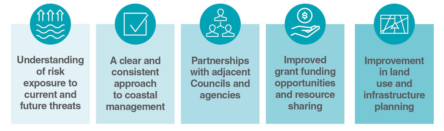
In summary, some of the key benefits of having a certified CMP in place are:
Implementing the CMP
The CMP outlines 67 management actions, 61 to be delivered by Council, focusing on issues like reducing coastal erosion and safeguarding our beaches. It helps us plan for and mitigate risks from coastal erosion, both during normal conditions and severe weather events, ensuring community safety and protecting infrastructure.
| 67 management actions | identified across the open coastline, inner port and outer port |
|---|---|
| 61 actions | to be delivered by Council over 10 years |
| 33 actions | scheduled for delivery in year one |
| Partial funding | secured through the Special Rate Variation |
| Additional funding | being sought from the Australian and NSW Governments |
| CMP is certified by the NSW Government | opening the door to funding support |
Implementation commenced in early 2025, and the first major on-ground project began in October 2025.
Status: Awaiting funding
The coastal erosion hazard investigation is a key project. Funding has been applied for and we are currently waiting for an outcome of the application. Many of the year one actions cannot be started until this piece of work is complete, including:
- Developing and implementing a coastal hazard monitoring strategy
- Undertaking a coastal erosion hazard investigation for the Inner and Outer Port
- Developing a program for monitoring coastal structures owned by Council
- Preparing planning proposals to manage coastal hazard risks
- Documenting long-term strategies for roads at risk from tidal inundation
- Installing tide gates/flaps on priority stormwater outlets
- Updating emergency action plans for Council buildings in coastal inundation areas
- Adopting a Coastal Vulnerability Area for the study area
- Environmental protection works at Soldiers Point Littoral Rainforest and Aboriginal Place
- Maintaining vegetated riparian corridors through development processes
Status: Completed
Recruitment is completed for a team that will focus on coastal public domain projects, including dune revegetation, sand nourishment, sand scraping, and infrastructure repairs.
Status: In progress
Some actions are part of normal Council operations and will continue to be programmed and actioned as normal:
Beach compliance monitoring
Ongoing compliance monitoring and enforcement of regulations relating to unauthorised 4WD access and off-leash dog walking on Council managed land.
Traditional Owner engagement protocol
Developing an engagement protocol and strategy for Council engagement with Traditional Owners and Knowledge Holders.
Boating and Fishing Infrastructure Plan
Progressing implementation of the plan across Port Stephens.
Fishing waste disposal support
Supporting the community to dispose of recreational fishing waste appropriately.
Major project collaboration
Working collaboratively and sharing information about major projects proposed for the open coastal waters to ensure appropriate consideration of the CMP vision and objectives.
Corrie Channel dredging advocacy
Advocating for a State Government commitment to funding the delivery of ongoing, long-term maintenance and navigational dredging of Corrie Channel.
Marine Parks engagement
Engaging with NSW DPI on the implementation of the Marine Parks Network Management Plan within the Port Stephens-Great Lakes Marine Park.
Water quality monitoring program design
Designing a water quality monitoring program for Port Stephens estuary consistent with DPE's Risk-based Framework.
Water quality data sharing
Entering into a data sharing agreement to enable sharing of historical and ongoing water quality monitoring data.
Water quality monitoring implementation
Implementing the Port Stephens Water Quality Monitoring Program and undertaking annual reporting.
Pest and weed control (Awaiting funding)
Undertaking pest and weed control management activities on Council owned or managed land in the coastal zone, including weed control, reducing pest species numbers, and monitoring.
Mambo Wetlands protection works (Awaiting funding)
Environmental protection and other works, including annual weed control programs, bush regeneration, feral animal control, fire trail maintenance, and periodic mosaic burning.
Some actions are beyond our control and need to be actioned by other government agencies or organisations. A project control group is being established with representatives from these different groups to oversee implementation of the CMP:
Hunter Water: Wastewater pump station upgrades
Investigating wastewater pump stations in the Port Stephens catchment that require upgrading to reduce the risk of wastewater overflows.
Hunter Water: Beachwatch monitoring
Continuing the Beachwatch monitoring program for recreational water quality at ocean beaches.
Frequently Asked Questions
The Port Stephens Coastal Management Program (CMP) is a 10-year strategic plan that provides a coordinated framework for managing our coastline. It sets out 67 management actions to address coastal hazards, protect community assets, and increase resilience to climate change impacts.
The CMP is partially funded through the Special Rate Variation. Council is also actively seeking additional funding from the Australian and NSW Governments to support the full implementation of the program. The 10-year plan will cost over $16 million.
The CMP covers three main areas: the open coastline from Fingal Bay to Stockton Beach, the outer port east of Soldiers Point, and the inner port west of Soldiers Point.
Implementation commenced in early 2025, with the first major project starting in October 2025 at Shoal Bay and Conroy Park. Works are being rolled out progressively across the year. This page will be updated regularly with project timelines and progress.
Some actions, particularly the coastal erosion hazard investigation, require additional funding beyond Council's current budget. We have applied for grants and are awaiting outcomes. Many other year one actions depend on this investigation being completed first.
This page will be updated regularly with project progress. You can also subscribe to the Your Port e-newsletter, follow Council's social media channels, or check the Projects and Works page on our website for specific project updates.
Key documents and links
- Port Stephens Coastal Management Program (CMP)
- Council report – 27 February 2024
- Draft Port Stephens Coastal Management Program summary document (PDF 11.1 MB)
- Community Update: Management Options June 2023 (PDF 2.8 MB)
- Coastal Hazards Fact Sheet - May 2023 (PDF 3.3. MB)
- Stage 3 start community update - March 2023 (PDF 3.4 MB)
- Coastal Management Program Stage 3 Report (PDF 34.8 MB)
- Coastal Management Program Stage 2 Report (PDF 185.3 MB)
- What are our coastal hazards? Community update - November 2020 (PDF 520 KB)
- Coastal Management Program Stage 1 Scoping Study Key Points (PDF 1.6 MB)
- Coastal Management Program Stage 1 Scoping Study Full Document (PDF 3.3 MB)
- Coastal Management Plan Stage 4 Report (PDF 116.3 MB)
Environmental Assessments
- Birubi Environmental Assessment
- Fingal Bay Environmental Assessment
- Shoal Bay Environmental Assessment
- Corlette Environmental Assessment
- Corlette 2 Environmental Assessment
- Nelson Bay Foreshore Environmental Assessment