The Future of Fullerton Cove

Fullerton Cove precincts map

Housing in Port Stephens

The NSW Government is predicting that another 20,000 residents will call Port Stephens home over the next 20 years. This forecast has driven the review of housing across Port Stephens.
We’ve developed a new Port Stephens Local Housing Strategy and Housing Supply Plan. This Strategy is designed to set the vision for future housing growth across Port Stephens and focuses on three main areas - housing diversity, housing affordability and housing supply.
Council identified the Fullerton Cove Precinct in the Housing Supply Plan as a key site in delivering new housing in Port Stephens.

Why has Fullerton Cove been identified?

Fullerton Cove is located within 20 minutes of the Newcastle CBD as well as key employment areas such as Newcastle Airport, RAAF Base Williamtown and Tomago industrial precinct, making it an ideal location for new housing.

A large proportion of the precinct is highly disturbed, having been cleared for the extraction of heavy mineral sands, and is flood free. The remaining parts of the precinct are considered to be either native bushland or rural land.

Due to its proximity to the Williamtown RAAF Base, the precinct sits within the broader Williamtown Management Area for PFAS contamination. As a precaution, the Department of Defence funded the extension of reticulated water services to residents within the management area. The reticulated sewer system was also extended to just north of the precinct.

The extension of reticulated water and sewer services has made reticulated sewer within the precinct economically feasible, preventing the need for on-site sewer management for future development. Together with the relatively unconstrained nature of the land, this change in circumstances has provided an opportunity to develop the precinct for urban purposes.

What is being proposed?
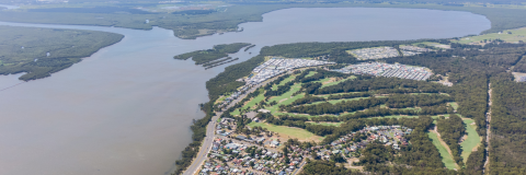
It is envisaged that the whole precinct could deliver approximately 840 dwellings across a range of densities, which may include detached single dwellings and medium density development. The housing is to be supported by a neighborhood centre to service the daily retail needs of the new residents.

The following land uses (zones) will likely be included:

  • Residential
  • Commercial (daily needs)
  • Open spaces
  • Environmental conservation.

Whether or not land is suitable for rezoning, and potential zone boundaries will be determined once detailed studies have been finalised.

What does this mean for my land?

A lead proponent is preparing a planning proposal and undertaking a number of supporting studies, at their cost, to rezone Precinct 1, as shown on the above map.

If your land is within the Precinct 1 planning proposal area, and if the planning proposal is supported, your land may be rezoned. At this stage, we don’t know the exact zone boundaries, but will have a better idea once the studies are undertaken and the planning proposal is lodged. Landholders within the precinct will be notified when the planning proposal is lodged.

The rezoning process can take up to 18 – 24 months to complete.

For Precinct 1, the lead proponent is organising and paying for all of the studies and assessments needed to support the rezoning, such as soil sampling or flora/fauna assessments. The proponent’s consultants may need to access land in Precinct 1 to undertake these assessments. The lead proponent has indicated to Council that that the cost of the rezoning will be at their expense.

Land in Precinct 2 is not being included in the abovementioned planning proposal.

What does it mean for rates?

If your property is rezoned, Council rates are likely to increase to reflect the land’s new potential uses.
Council rates are calculated using land value. Land value is market value excluding improvements on the land such as dwellings and buildings. Land is valued for rating purposes by the NSW Valuer General every three years. Land is valued at its highest and best use. A wide range of factors that can impact the value of land are considered, including zoning, the availability of services and development constraints such as flooding.
If your property is rezoned, land value and consequently council rates may increase to reflect the new potential uses. Speculators sometimes purchase land that is likely to be rezoned well before the rezoning and pay a higher price that reflects the subdivision potential. Land subdivision may involve significant costs and the rezoning may not increase the land value due to the high development costs.

I don’t want my zoning to change

If your land is rezoned as part of Precinct 1, you will not be forced to sell, develop or change the use of your land.
During the exhibition period, you will be given an opportunity to provide feedback on the planning proposal. This feedback will be considered by elected Council prior to a final decision being made.

What are the next steps for Precinct 1?

Once a planning proposal for Precinct 1 is lodged, Council will assess it in accordance with the legislated process.  

We will keep landholders informed as this process progresses. In addition, there will be a formal public exhibition period in which the impacted community is invited to make submissions on the planning proposal for Council's consideration.

Once rezoned, landholders will be able to lodge development applications to develop their land.

What are the next steps for Precinct 2?

Precinct 2 landholders are encouraged to talk to Council about the rezoning process should they wish to pursue the rezoning of their land.